
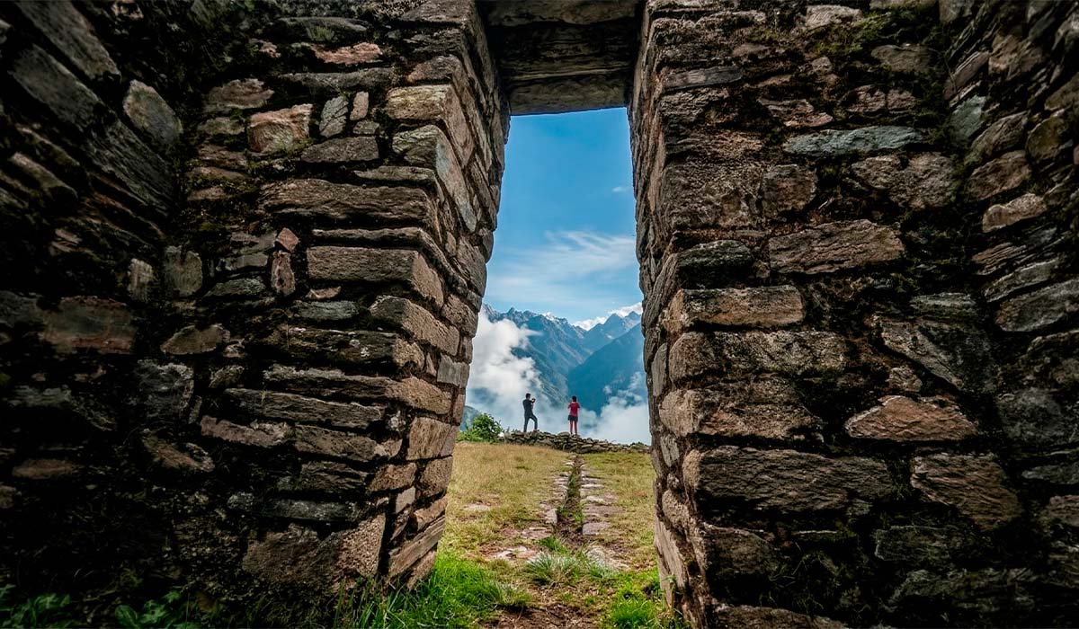
For those seeking an Indiana Jones-style adventure and a unique view of one of the world's wonders, the spectacular Llactapata Viewpoint is a must-see. Hidden within the lush cloud forest to the west of the sanctuary, this mysterious ceremonial centre is one of the highlights of the Salkantay Trek. Unlike the busy main trails, Llactapata offers seclusion and a direct, breathtaking view of the Machu Picchu citadel across the valley.
This strategic observation point provides hikers with a 'secret' view of Machu Picchu that few travellers ever witness or photograph. From these heights, you can take in the vastness of the Urubamba Valley and the Vilcabamba mountain range before beginning the scenic descent towards Aguas Calientes. It is the perfect reward for those who choose the rugged beauty of the Salkantay route.
What truly sets Llactapata in Peru apart is the masterful topographical planning of the Inca engineers. Strategically built along the mountain ridge, the complex features a collection of well-preserved Inca ruins, including solid stone enclosures, ceremonial plazas and agricultural terraces. Historically, Llactapata served as a high-altitude shrine and a vital control point, perfectly aligned with the sun and sacred mountains.
The Llactapata Viewpoint sits atop a steep mountain ridge above the Urubamba River basin in the district of Santa Teresa, Cusco Province, La Convención Region. This archaeological site sits at an altitude of approximately 2,750 metres above sea level, fully immersed in the lush, humid jungle that surrounds the historical sanctuary. To reach this location, hikers must undertake a challenging climb lasting several hours, starting from the coffee-growing valley of Lucmabamba and crossing the dense, biodiverse paths of the cloud forest during the final days of the Salkantay Trek.
This place is truly extraordinary thanks to its location, which the Incas selected to maintain a direct visual and spiritual connection with the main citadel, located just four kilometres away in a straight line to the east. From the edge of these ancient observation terraces, travellers can not only see the backs of the famous Huayna Picchu and Machu Picchu mountains, but also the dizzying depths of the Vilcanota River canyon.
The contemporary history of this site began in 1912, when the renowned explorer Hiram Bingham rediscovered the Inca ruins in the Huaquina sector, which had been hidden by dense vegetation. Later scientific research also determined that these buildings served as an important resting point and strategic control point closely linked to the original route to the citadel. It is not only the distance of barely four kilometres that demonstrates this deep connection with Machu Picchu; the precise astrological alignment and the complex shared drainage system that unified both ceremonial centres under the same urban design also play a part.
What makes this complex extraordinary is the way archaeologists tried to reveal its secrets in 2003. Researchers Hugh Thomson and Gary Ziegler flew over the area using advanced remote sensing cameras with infrared thermal imaging. However, this ambitious technological endeavour was only partially successful, as the Vilcabamba region is shrouded in dense clouds after midday, preventing the stones from absorbing enough sunlight to be detected from the air. This constant weather limitation also forced the expedition to rely on more traditional ground survey methods, which proved much more effective for mapping the area and establishing this rugged mountain territory as a place where nature jealously guards its secrets.

To avoid any confusion when planning your trip, it is important to note that there are two sites in the Cusco region with the same name that serve completely different purposes and are located in different places. While the main focus of our article is the small ceremonial viewpoint hidden along the Salkantay route, the other site is a vast and impressive agricultural centre situated where the Cusichaca and Urubamba rivers converge, also known as Patallacta (Llaqtapata).
Therefore, this second, large pre-Columbian settlement can only be visited by hikers who have booked the permits required to walk the Classic Inca Trail. This marks a logistical difference between the two experiences.
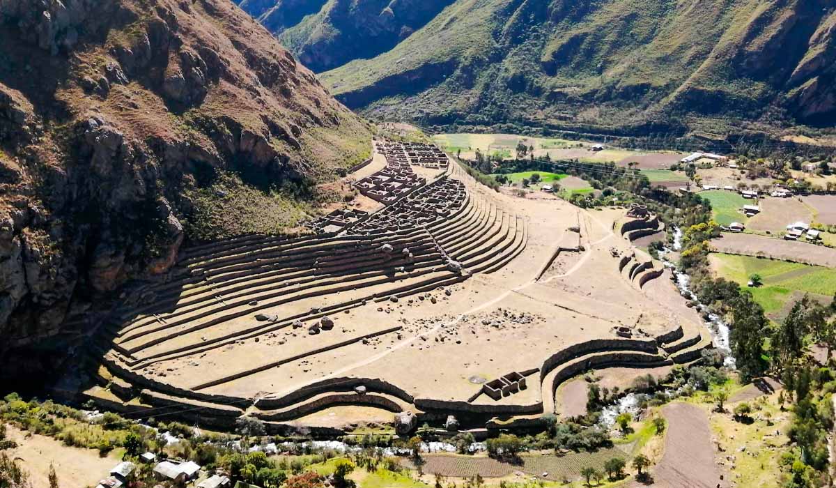
Patallacta (Llaqtapata) - Inca Trail
The second Inca Trail complex is truly extraordinary, not only for its monumental size, but also for its huge farming terrace system, which served as the main granary and food supplier for the entire area. Unlike our intimate viewpoint, which offers a direct view of one of the wonders of the world, the large agricultural settlement in the valley is notable for its own architecture of terraces, urban buildings and complex drainage systems.
Understanding this important geographic duality will also help you to choose the right expedition for you, with our hidden Llactapata viewpoint being an ideal option for those looking for that secret, postcard-perfect view of Machu Picchu from above.
Llactapata Machu Picchu - Salkantay Trek
The Llactapata Machu Picchu archaeological complex is located above and below a long orogenic ridge that extends from Nevado Salcantay, the highest peak in the region, to the Urubamba Canyon in a northerly direction. The complex faces Machu Picchu and the two hills on either side of it: Machu Picchu Hill and Huayna Picchu Hill. The ridge on which Machu Picchu is located is about 5 kilometres east of Llactapata and is separated from it by the deep Aobamba valley, through which flows a river fed by the melting glaciers of Nevado Salkantay.
The archaeological zone consists of diverse groups of buildings related to each other, as well as agricultural areas, urban remains of a lower category, and interconnected roads and driveways. All of these features are arranged across a surface area of several square kilometres. The area is divided into five sectors. The characteristics and features of each of these have been determined and diagrammed in site plans. Individual structures and isolated elements are indicated in the general site map as 'scattered ruins' or 'others'. Some individual site plans are less detailed than others, indicating the need for additional information and research. The Llactapata archaeological zone measures approximately 4 km long by 2 km wide and contains more than 80 man-made structures and elements, which we have organised into five sectors. The area is located 4.5 km from Machu Picchu.
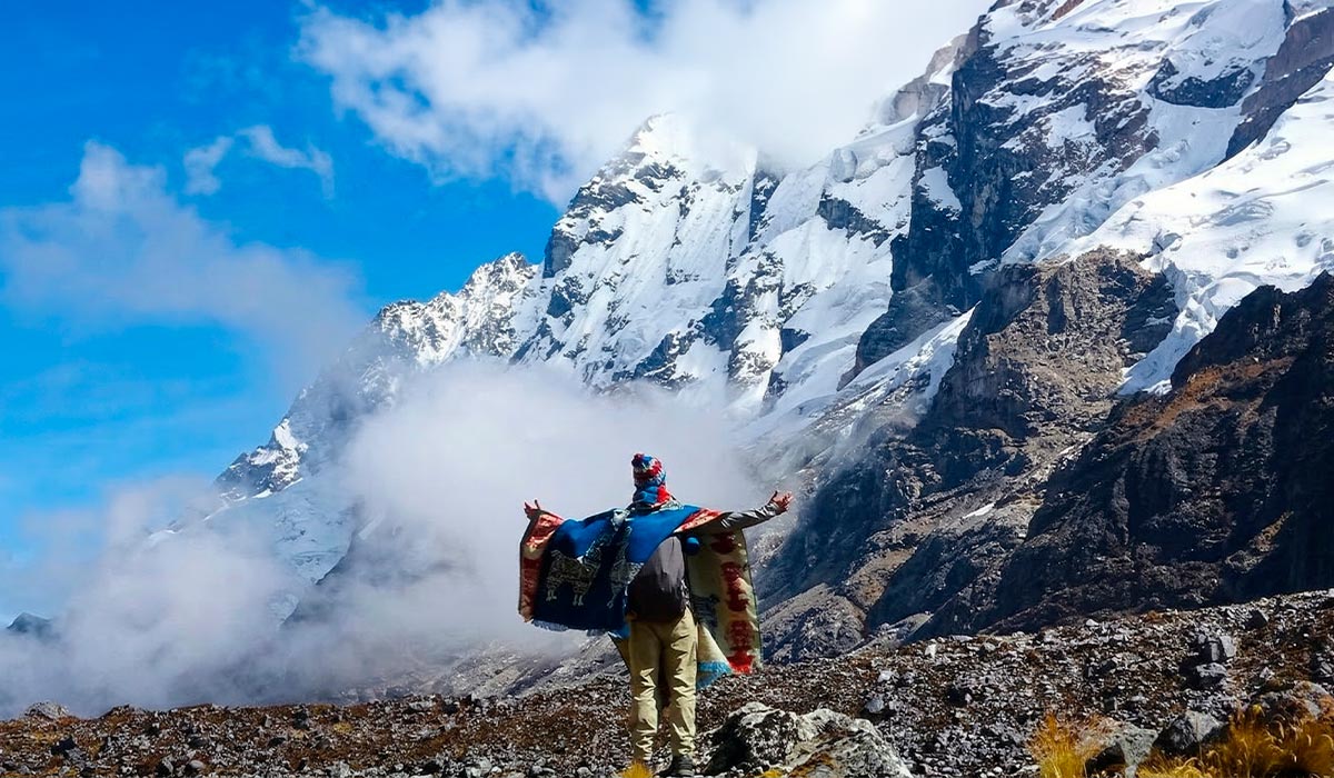
The imposing Salkantay mountain is one of the highest and most sacred in Peru. It offers travellers the chance to embark on a truly epic expedition along an alternative, historic route. This challenging five-day, four-night journey will also take you through the mysterious Llactapata complex, an ancient Andean settlement with impressive farming platforms which, according to research, may have served as strategic granaries to supply this region of the empire.
What makes this trek extraordinary is the huge adrenaline rush experienced while travelling through such extreme and ever-changing landscapes en route to the 'Lost City of the Incas'. Throughout this excursion, hikers will be captivated by the beauty of the valleys and the abundance of flora and fauna in the surrounding jungle. This unforgettable journey culminates in a spectacular finale, with hikers reaching the summit of Llactapata to admire the Machu Picchu sanctuary from afar, making this one of the best hiking routes.
 +51 84 217 551
 +51 997 434 941
 Av Tupac Amaru PP-10B, Santiago, Cusco, Peru
  info@incatrailmachu.com
 www.incatrailmachu.com


