
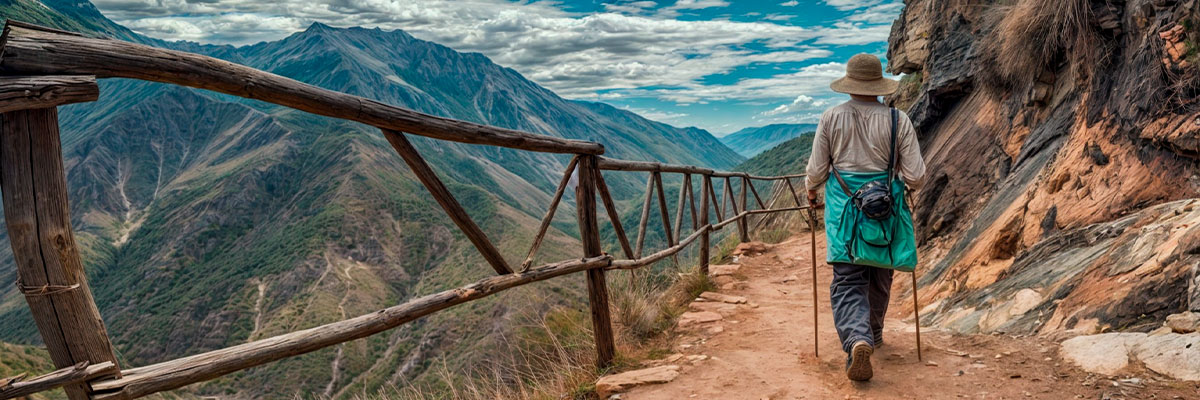
The Choquequirao to Machu Picchu trek is a magnificent 9-day journey that takes you through the most scenic trail connecting two remarkable Inca cities. Walk through on the legendary Inca Trail, passing through ancient ruins and sacred mountains (Apus). This expedition offers an immersive experience in Andean and natural history, allowing you to explore the best archaeological sites in Cusco!. The Combo Expedition will take you to the Citadel of Choquequirao, the latest archeological destination in southeastern Cusco Peru, and to the world-famous Inca Sanctuary of Machu Picchu. We propose you a 9-day expedition will transport you through time, , amidst lush vegetation, imposing snow peaks, and deep valleys.
Along the way, you'll have the opportunity to visit remote native communities such as Maizal and Yanama, adding a cultural dimension to your journey. Bring your photographic equipment along, as this journey is the most picturesque trip offered in the Cusco area.
The views from Choquequirao to the ruins are magical and really beautiful, there still exists unexplored places to explore while you're listening to the histories of each monument you find on the road.
However, this trek is challenging because the trails are difficult to pass, it can be accomplished with good physical condition, you can realize it without trouble. We provide top-quality camping equipment, and a balanced and energizing diet.
If you're hungry for an unforgettable adventure, the Combo Expedition will exceed your wildest dreams! Join us on this extraordinary journey through the heart of the Inca Empire."
Group Size: Min 2 and Max. 8 trekkers.
Sustainable Tourism: Inca Trail Machu is very keen and happy to promote and practice sustainable tourism by being eco-friendly and supporting local communities
Physical Activity: 4-Difficulty - Some points are high.
Service Level: All Inclusive.
Age Requirement: 4+. Please note: that all participants under the age of 18 must be accompanied by an adult.
Permits: Included the Choquequirao and Machu Picchu Ticket.
Inca Trail Machu Staff: Professional tour guide, Trekking chef, Muleteers, and horses during the 5-days hike.
Personal horses: Our horses will carry your personal belongings up to 7 kg per person!
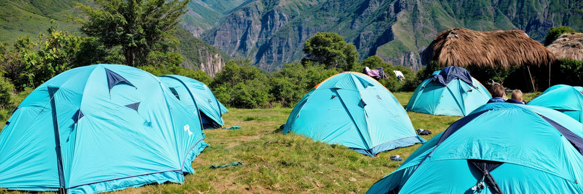
Accommodation: 7x campsite and 1x hotel in Machu Picchu.
Meals: 8x breakfast, 8x lunch, 8x dinner, 6x afternoon tea. (Please allow USD 30-50 for meals not included).
Transportation: Transportation by private vehicle, 1x train ticket return;
Camping equipment: A double tent, therm-A-Rest mattress, and a sleeping bag;
Day 01: Cusco - Cachora - Playa Rosalina
Day 02: Playa Rosalina - Marampata - Choquequirao
Day 03: Choquequirao - Maizal
Day 04: Maizal - Minas Victoria - Yanama
Day 05: Yanama - Totora
Day 06: Totora - Collpapampa - Wiñaypoco
Day 07: Wiñaypoco -La Playa - Lucmabamba
Day 08: Lucmabamba - Aguas Calientes
Day 09: Aguas Calientes - Machu Picchu - Cusco

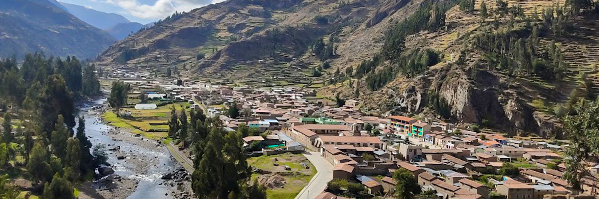
We leave Cusco early in the morning by private vehicle. After 4 hours, we reach Cachora (2,850 m/9,350 ft), a small village and the starting point of this hike. We start descending to the Apurimac river valley having sensational views of far away snowy peaks. We have first opportunity to see Choquequirao mountain on the opposite site of the valley after a couple of hours of walking. The way to Choquequirao leads through a highland jungle (or Andean jungle) so the weather is warm, humid and rainy resulting in a very rich tropical vegetation and fauna too. Of the vegetation, lets name native trees such as lambram, chachacomo and inkallaulli. There are also cedars, medicinal plants, ferns, orchids, bromelias, etc. Representans of local fauna are deer, a spectacled bear, felines, foxes, skunks, birds such as a variety of of hummingbird species or Andean condors crisscrossing the sky in the afternoons. In the end, we reach our first campsite at Playa Rosalina (1,550 masl/5,115 ft) located at the shores of the Apurimac river.
After a solid breakfast, we start a gradual ascend to Marampata (2,850 m/9,350 ft) consequently, the treks gets harder; however, it offers spectacular views of the deep Apurimac River Canyon and the river itself that is the main tributary of the Amazon River! We can also spot condors soaring in the mountains! When we get to Marampata, we have lunch there and a short rest. At around 4 pm, we arrive to the enigmatic and fabulous lost Inca city - Choquequirao (3,100 m/10,168 ft)! The city is considered bigger in extension than the Sancturary of Machu Picchu! Our Tour Guide shows us around the city and explains us about its each part such as Hauqaypata (main square) with the principal Sun Temple, Urin (upper square) with its open temple, Ushno (ceremonial platform), houses of priests, qolqas (storages), irrigation channels and agricultural terraces. However, investigation works have not discovered all the site yet so we can still expect more surprising excavations in future!! From there, we also can view spectacular mountain scenery surrounded by the cloud forest! We set a camp near the archaeological site and overnight.
The Archaeological Park of Choquequirao is situated in southern Peru on the right side of Apurimac River, at the slopes of the same named mountain just next to Qoriwayrachina Mountain of the Salkantay Mountain Range. The park covers an area of 1,810 hectares.
Choquequirao was constructed probably between the second part of the 15th century and the first decades of the 16th century, it means the period when Incas started to conquer new territories of Antisuyo (located northwest of Cusco in high Andes inhabited by so called “Antis” – a collective name for the many varied ethnic groups living in this area). Choquequirao is considered as one of the last resistance bastions and refugees of the Incas, who abandoned Cusco in 1535 by order of the Incan ruler Manco Inca to regroup as Cusco was besieged by Spaniards.
Although, there were a couple of persons, who wrote about or visited Choquequirao, this Incan site had not received a big attention until the American historian Hiram Bingham along with the topographer Clarence visited and described the place in details in 1909!
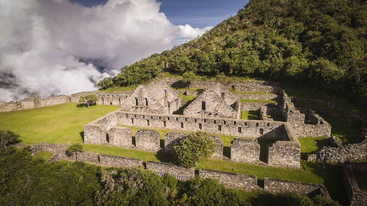
Due to its location, it is probable that it served as a very important religious centre occupied by Inca’s priests. It also served as a big political, economic and cultural centre that was in touch to the coastal, highland and jungle parts of the empire. The site ended unfinished as well as it let many questions unanswered to confuse today’s archaeologists.
After breakfast, we leave the Incan city of Choquequirao to first gently hike for 3 hours up to the Choquequirao Pass (3,300 m/10,890 ft) and after that, we start descending to Rio Blanco (White River; 1,900 m/6,270 ft) entering a cloud forest. There, we can appreciate polylepis trees (native mountain trees with shredded, multi-layered bark), epiphytes, bromeliads, orchids, diverse bird species as well as water fountains. Lush vegetation of the cloud forest still cover a part of the Inca farming terraces of Pinchiunuyoc (2,487 m/8,160 ft). After our Tour Guide explains us about this Inca site, we keep descending passing through coca plantations and gradually changing nature into a dry Andean forest. After having lunch there, we climb for another three hours towards the village of Maizal (3,000 m/9,900 ft) where we set up our next campsite. From this natural view point, we can appreciate imposing views of the gorges of Yanama and Yurahmayo that later join the Apurimac River Canyon! Also the sunsets there are really stunning!
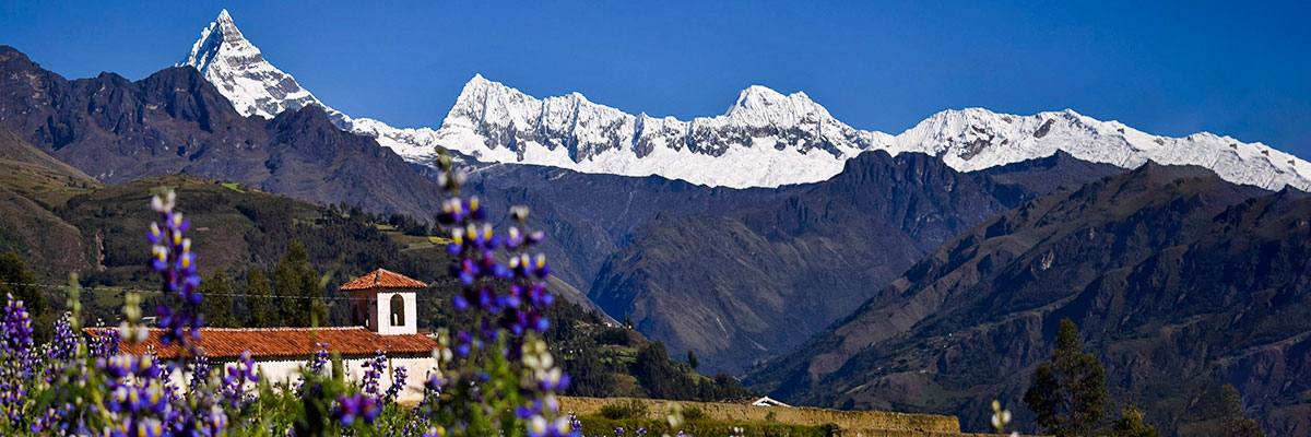
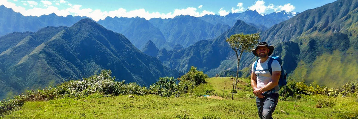
We start ascending after early breakfast towards the Victoria Pass (4,150 m/13,695 ft). After a 4 hour steep ascend, we reach the Minas Victoria, an Incan and later colonial silver mining centre that is abandoned nowadays. Then, we hike along a hill called Qoriwayrachina, a place where archaeological explorations have been done recently. Closer to the Victoria Pass, we start following an incredibly well- preserved authentical Inca trail with stone steps in its middle! When we reach the Victoria Pass, we enjoy a breathtaking view of the snow-capped mountains of Humantay (5,700 m/18,700 ft) and Salkantay (6,271 m/20,574 ft), considered by local people as the "guardian spirit of the jungle"! Finally, we descend to the village of Yanama (3,800 m/12,540 ft) where we overnight in another campsite with views of the Yanama River below us and Pumasillo Mountain above us.
We start hiking in the morning towards the Yanama Valley passing farmar´s fields and lush vegetation to later overcome the highest pass of the trek - Yanama Pass (4,668 m/15,315 ft). This causes that today´s trek gets harder and the day is challenging! However, it offers spectacular views of a chain of snowy peaks such as the Sacsarayoj and Padreyoc Mountains! If we are lucky, we can also spot majestic condors flying above surrounding cliffs. When reaching the pass, we are able to observe a pile of stones that have been added by visitors to thank to Apus (a mountain god) for a safe journey and good luck! Then, we descend to the Totora Pampa where our next campsite is situated near the village of Totora (3,630 m/11,979 ft).
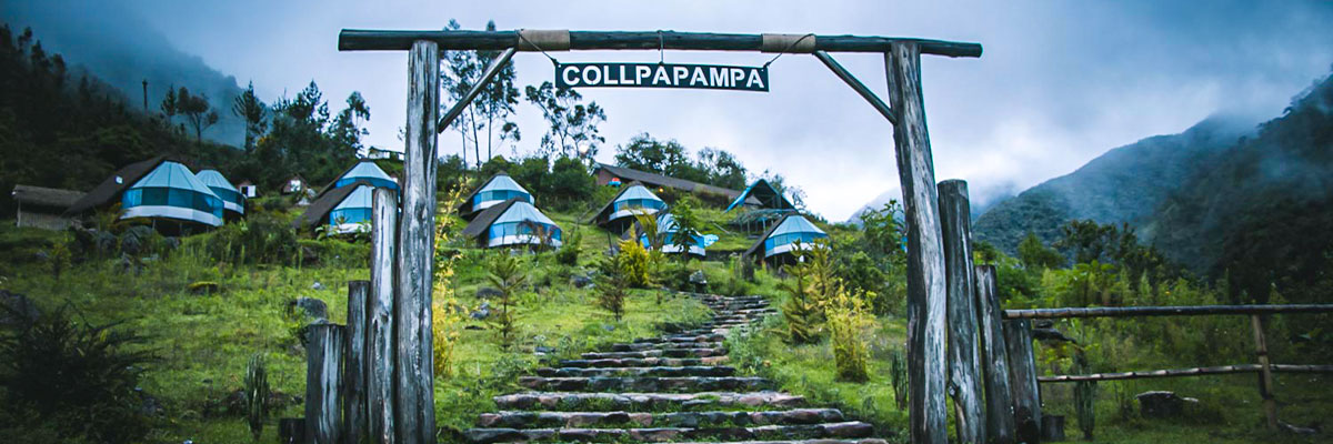
We start trekking today following the flow of the Totora River to later descend gradually to a high (or mountain) jungle - known in Spanish as the "Ceja de selva" (literally: jungle´s eyebrow) so we can notice the quickly changing vegetation and the temperature getting warmer. In the high jungle, we can view its typical lush vegetation of wild orchids and bromeliads as well as watch a variety of beautiful birds. Then, we descend to bamboo groves. Do not forget to look back sometimes as you can see snow peaks framed by bamboo fronds behind you! We pass through the village of Luscamayo and after a 4-hour descent; we reach a tiny settlement of Collpapampa (2,850 m/9,348 ft), a place of our lunch break. Afterward, we keep descending having the Santa Teresa River on the left side observing small coffee and tropical fruit´s plantations on the way. In the end, we get to the foothill of the Wiñaypoco Mountain where we set a campsite (2,680 m/8,793 ft).
After a healthy breakfast, the trail continues down towards the Aobamba River passing through bamboo groves, orchards, and coffee plantations providing some perfect birdwatching opportunities (e.g. hummingbirds, woodpeckers). We walk on some fantastic untouched paths where strawberries grow at our feet and passion fruits are just above our heads, this all decorated with begonia and purple orchid rugs! After 2 and half an hour, we arrive at a tiny place called La Playa (2,100 m/6,890 ft) where we have a small break accompanied by lunch with fresh fruits! Later, we keep trekking until we get to the village of Lucmabamba (2,250 m/7,381.89 ft), a place of our next overnight. This is another easy trekking day, during which we enjoy observation of lush vegetation as well as we get familiar with diverse plants cultivated in this area such as banana, mango, papaya, avocado, coca leaf, coffee, etc. The area is also a habitat of a spectacled bear and many parrots.
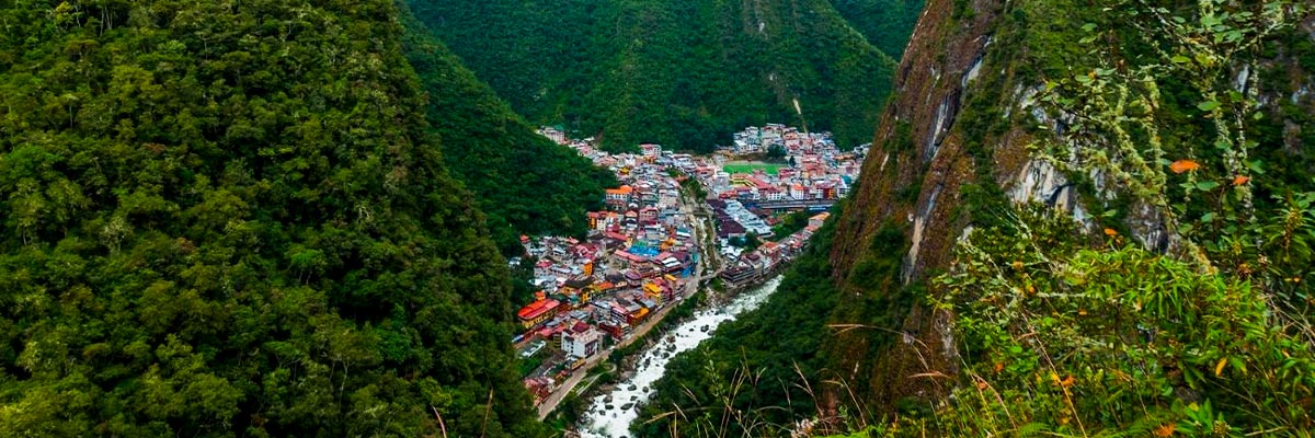
We wake up early today as a nice uphill walk awaits us providing us with some amazing views of a valley. After a 5 hour hike, we enjoy our last lunch at the recently restored Incan ruins of Llaqtapata (2,650 m/8,694 ft) from where we can view both, Machu Picchu and the Salkantay Mountain! Then our Tour Guide shows us around the ruins! From there, we are given an opportunity to see the main highlight of South America - Machu Picchu, from an exceptional point of view that a majority of tourists will never see!! Then, we descend easily for 3 hours to the Hydroelectric Plant (Hidroelectrica; 2,050 m/6,726 ft). There, we follow trails and the Vilcanota River leading us to our last night in the Machupicchu village (Aguas Calientes - 2,042 m/6,700 ft), located at the foothill of Machu Picchu Mountain!
After early morning breakfast, we hike for 2 hours up to the mysterious city of Machu Picchu (2,430 m/7,972 ft) we enter for the early morning best photo opportunities! Then our Tour Guide shows us around the Incan city and explains us its history and purposes. After the guided tour, we have the opportunity to climb Huayna Picchu for about 45 minutes, a peak overlooking Machu Picchu that is perfect for taking panoramic photos of the Inca city. Visiting this complex requires an additional ticket for Circuit 3, which means an extra cost and advanced booking. In the afternoon, we return by train to Ollantaytambo (alternatively to Poroy), from where we are taken by van back to Cusco.
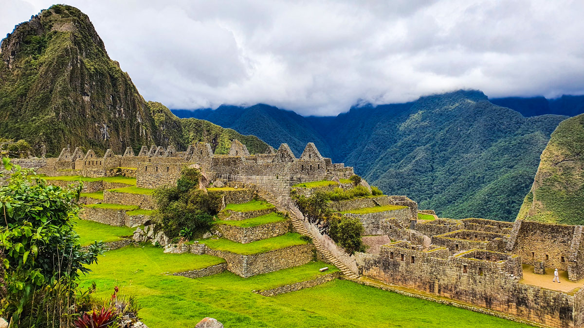
Machu Picchu is both, the best and the least known site of the Incas as it is not mentioned in any Spanish conquistador´s chronicle so contemporary archaeologists can not do anything more than just speculate on its functions. Local Quechuan farmers had known about Machu Picchu for centuries before an 11 year old boy showed the American historian Hiram Bingham (who was in a search of Vilcabamba) this site on the 24th of July 1911. At that time, all the rest of the world became aware of its existence. However, the site was covered with thick vegetation so Hiram Bingham along with his team returned and within the years of 1912 and 1915 cleared its surface. Over the years, plenty of work has been done on excavating and studying the site. Despite these efforts, many unanswered questions remain.
Meal budget: Please allow USD 30-50 for meals not included.
Solo Traveler: Please note that if you have booked the "Solo Traveler" option for this trek, you receive your own single tent for all nights.
Local flights: No local flights are included in the trek´s price! If you need it, let us know please, we have the competitive price.
 +51 84 217 551
 +51 997 434 941
 Av Tupac Amaru PP-10B, Santiago, Cusco, Peru
  info@incatrailmachu.com
 www.incatrailmachu.com


